Add custom map layers to GaiaGPS
Gaia GPS is regarded as one of the best backcountry GPS apps for your smartphone. They offer a wide variety of base maps to choose from, but one of my personal favorites, called Open Topo, happens to not be one of them.
What makes Open Topo a terrific choice for outdoor adventures? It has nice shaded relief (which makes features like ridges and gullies much easier to see), updated trails and roads, and land cover, such as forest, rock, or snow. (One potential curveball for Americanos - elevations and contours are in meters.)
Go have a look yourself. Go to opentopomap.org and zoom into your favorite part of the world.
Here’s a screengrab of Mount Rainier in Open Topo. Pretty cool, eh? Like I said, elevations are in meters.
The one small downside is that it is not part of the Gaia GPS app.
The good news is, with a little computer sorcery, you can add this as a custom map layer to your Gaia GPS phone app. Here's how to do it.
These steps might sound a little complicated, but it's pretty straightforward. Keep this webpage open in a browser tab so you have a reference.
Here's a nice video that shows how to do it, using Google Earth.
Here are the step-by-step instructions, for a different map source as mentioned above, Open Topo.
1. On a desktop computer (not your phone), go to GaiaGPS.com. Log in to your account, or create an account if you don’t have one.
2. Click your user name (top right of screen), and from the drop down box select "Map Sources".
3. Click "Import an External Map Source".
4. In the “Name the Map” box, give it a name. I suggest a simple, descriptive, name, like “Open Topo custom“.
5. Scroll a bit lower, locate "Paste your modified link here"
6. Copy and paste this link in that box:
https://c.tile.opentopomap.org/{z}/{x}/{y}.png
7. Scroll to the bottom, click "Add this Map Source"
Go to your phone.
8. Make sure you are signed in to your Gaia account on your phone. [Settings icon > Account > Login) and that “Sync/Backup” is toggled on.
9. Restart the app.
10. Tap the Map Sources icon, top right of your screen. Tap Edit, then scroll to the bottom and tap “Custom Imports”.
11. You should see “Open Topo Custom” here, or whatever you decided to name it. Select this map layer to add it to your viewable layers. You should now be able to use Open Topo on your phone.
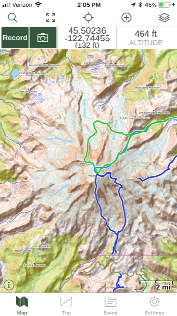
Below is a phone screengrab of Mt. Rainier in Gaia GPS Open Topo map layer, with climbing GPX tracks in blue and green.


