What's “shaded relief” on a contour map?
Shaded relief, also known as terrain shading, is a very clever way to make contour maps appear more three dimensional. With shaded relief, terrain features such as ridges and gullies appear much more prominent and recognizable. The shading works some magic between your eye and your brain to make what you're looking at appear 3D. It's really quite amazing!
Below is an example of the Eagle Creek Trail in the Columbia River Gorge in Oregon. (The red line is the wilderness boundary.) This first map is from the standard USGS 7 1/2 minute topographic map, with no shaded relief. At first glance, most people will see this as pretty much a spaghetti pile, with no obvious ridges or gullies visually jumping out. (Yes, if you know a bit about reading contours you can probably make out some of the terrain features, but that’s a different topic.)
Now, here’s a screen grab of the exact same area, with about 20% shading added to the map.
Magic! Notice how the ridgelines and the stream drainages are much more obvious? Most people find this map MUCH easier to read.
Before modern mapping software, cartographers tried to achieve this by using hand drawn shading. This was incredibly labor-intensive, but achieved some beautiful examples of cartographic art. Here's an example of some amazing Swiss hand drawn relief shading, near Mount Everest.
Fortunately, mapping software today makes it easy to add with just a few clicks. Many commercially produced maps have some sort of terrain shading added, but it’s also easy to make your own maps for free that have this helpful feature.
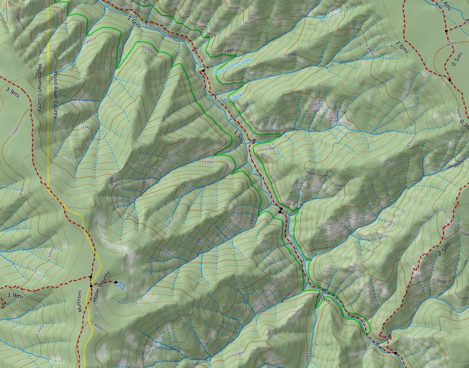
Probably the easiest way is to use the terrific mapping software Caltopo. In Caltopo, a fast way to get terrain shading is to choose the map base layer called MapBuilder Topo, from the top right menu. This map layer is a great choice for any sort of outdoor recreation, as it has updated roads and trails, a little bit of vegetation shading, and terrain shading.
Learn to easily make your own maps like this with Caltopo from this YouTube video.
Here's an example of the same Eagle Creek area, made in CalTopo with the MapBuilder Topo layer. Note that the distracting red wilderness area boundary is now easy-on-the eyes green, and the red-dashed line trails are much easier to see.
Finally, let’s look at the old school USGS topo map one more time. Ask yourself - which map would you rather use? The answer should be pretty obvious.
Finally, here's a short video I made on how to do this in CalTopo.


